

View from back of The Roaches (Morridge Hill Country Project area). Photo by Sarah Davison.
Morridge Hill Country
A Landscape Recovery Project
Staffordshire Wildlife Trust are supporting this two-year development project which is led by Peak District National Park Authority. Together with landowners the team are creating a joined up approach to nature and farming in the South West Peak.
There are over 20 local farmers and landowners involved in making plans for environmental enhancements of 2,900 hectares of land. These changes will generate sustainable income streams for farmers and boost wildlife. The project aims to show productive upland farming can go hand in hand with nature recovery, flood mitigation and carbon capture. The project is funded by DEFRA in conjunction with the Environment Agency and Natural England.
Why is this project needed?
Farmers are under increasing pressure and making a living from farming is getting harder. This innovative landscape recovery project enables them to explore alternative funding streams, providing better long-term financial stability.
Healthy habitats bring multiple benefits to our lives. They can help us address flooding, water quality, temperature regulation and food security.
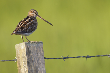
Farmers and land managers are already doing a lot for nature. Their land supports snipe, curlew and lapwing to name a few species. There is an opportunity to reinvigorate and diversify grasslands, rewet peaty areas and floodplains, create and connect more hedges and increase scrub and wood pasture. All actions which will increase resilience to climate change.
As the project moves into the delivery phase (in 2026) we will create a positive future for people and wildlife spanning the next 20 to 30 years. The project will also celebrate the area’s cultural heritage and create ways for people to get involved. This includes improving access, exploring ways of involving people from diverse backgrounds and offering volunteering opportunities.
Where is the project?
Morridge Hill County includes land between Gradbach and Warslow which is within one of the world’s most visited national parks. It’s also a working landscape, which is home to many families who have farmed this land for decades. It supports a range of wildlife too. Eye-catching moorland plants like bog asphodel and iconic birds such as curlew. The farmers, the National Park Authority, the Ministry of Defence and SWT are all custodians of this land. Together we will unlock the potential to make the land better, and more connected for nature.
What does the future look like?
We have a vision of a rich tapestry of healthy ecosystems that work in harmony and farmland which is more resilient to climate change.
During the development phase the team are creating project proposals. These will outline how the vision can be achieved. Including nature sensitive farming practices, so it can thrive alongside profitable and sustainable food production.
In spring/summer 2026 DEFRA will review and assess the project proposals. Subject to their approval, the project will transition to delivery phase later in 2026.
Tom Ellis Photography
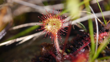
Round-leaved sundew (photo by MHC Project Manager Jackie Wragg).
What has the project team been doing?
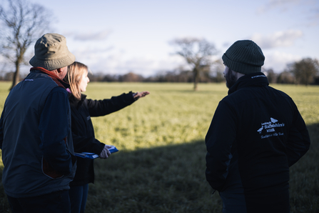
Throughout the development phase of the project the team have developed a deep understanding of the land and identified what opportunities there might be for each land manager.
We've met with each farmer to hear their ideas, aspirations and concerns so they can be addressed in the proposals. They've given detailed information about their land, livestock, finances and management methods.
Mapping and surveys have created a detailed helicopter view of the project area. Survey data has also set baselines on which to measure future impacts and informs decisions about what management is suitable where.

©Chris Lawrence
Peat and plants
Peat depth measurements have been taken and surveys completed to record the distribution of peatland plants, such as sphagnum moss (pictured).

Waxcap by Jackie Wragg
Fantastic fungi
Waxcaps are grassland jewels which are a characteristic feature of the area. We’ve surveyed which species are here and their distribution.

Land in the Manifold Valley area of the project by Jackie Wragg
A helicopter view
Mapping the landscape has highlighted opportunities for improved Ecosystem Services* and where habitat can be created or improved for wildlife.

Emma Ralls
A welcoming landscape
We’re also gathering ideas to celebrate the cultural heritage of the area and opportunities for it to be enjoyed by a diverse range of visitors.
*Ecosystem Services are the direct and indirect contributions nature has on human wellbeing and quality of life. They are the beneficial impacts generated when ecosystems function in a healthy way. For example, nature provides us with water, clean air and food - our crops rely on insect pollination and the complex biological processes that create soil.

Morridge Hill Country project logo - original image of Hen Cloud courtesy of Robert Lowton

Landscape Recovery logo

